
 Dyrestuy
Mikhaylovka
Mayskiy
Novobessergenevka
Tersky District
Lesnoy
Tertezh
Kuz'minskiye Otverzhki
Meshcheryaki
Dyrestuy
Mikhaylovka
Mayskiy
Novobessergenevka
Tersky District
Lesnoy
Tertezh
Kuz'minskiye Otverzhki
Meshcheryaki
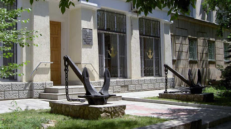
History Museum of the navigable channel of Volga-Don auf der karte, Wolgograd, Russland
Foto
Wo befindet sich History Museum of the navigable channel of Volga-Don
History Museum of the navigable channel of Volga-Don — lokale attraktion, die sich in befindet Ulitsa Fadeyeva, 35А, Volgograd, Volgograd Oblast, 400082 und gehört zur kategorie — museum. Durchschnittliche Besucherbewertung für diesen Ort — 4.6 (entsprechend 130 bewertungen, informationen aus offenen quellen und relevant für 2022).
Genaue Position — History Museum of the navigable channel of Volga-Don, auf der karte mit einer roten markierung markiert.
Sie können wegbeschreibung erhalten History Museum of the navigable channel of Volga-Don auf der karte von ihrem standort aus.
Was sonst noch interessant ist Wolgograd? Sie können alle Sehenswürdigkeiten sehen, wenn Sie auf die Stadtseite gehen.
Koordinaten
History Museum of the navigable channel of Volga-Don, Russland koordinaten im dezimalformat: breite — 48.519477080160414, länge — 44.556355198187354. Bei Umrechnung in Grad, Minuten, Sekunden History Museum of the navigable channel of Volga-Don hat die folgenden koordinaten: 48°31′10.12 nördlicher breitengrad und 44°33′22.88 östlicher längengrad.
Städte in der Nähe
Die größten Städte in der Nähe:
- Wolschski — 20 km
- Kamyschin — 165 km
- Wolgodonsk — 219 km
- Elista — 264 km
- Engels — 329 km
- Saratow — 330 km
- Schachty — 337 km
- Nowocherkassk — 361 km
- Astrachan — 374 km
- Luhansk
 — 381 km
 - Bataisk — 399 km
- Altschewsk — 420 km
- Balakowo — 430 km
- Stawropol — 449 km
- Taganrog — 451 km
- Horliwka — 479 km
- Tambow — 490 km
- Woronesch — 491 km
- Newinnomyssk — 493 km
Entfernung zur Hauptstadt
Entfernung zur Hauptstadt (Moskau) handelt von — 933 km.